9 Nights 10 Days
Daily Tour
15 people
___
The Most Beautiful Trek In Himalayas
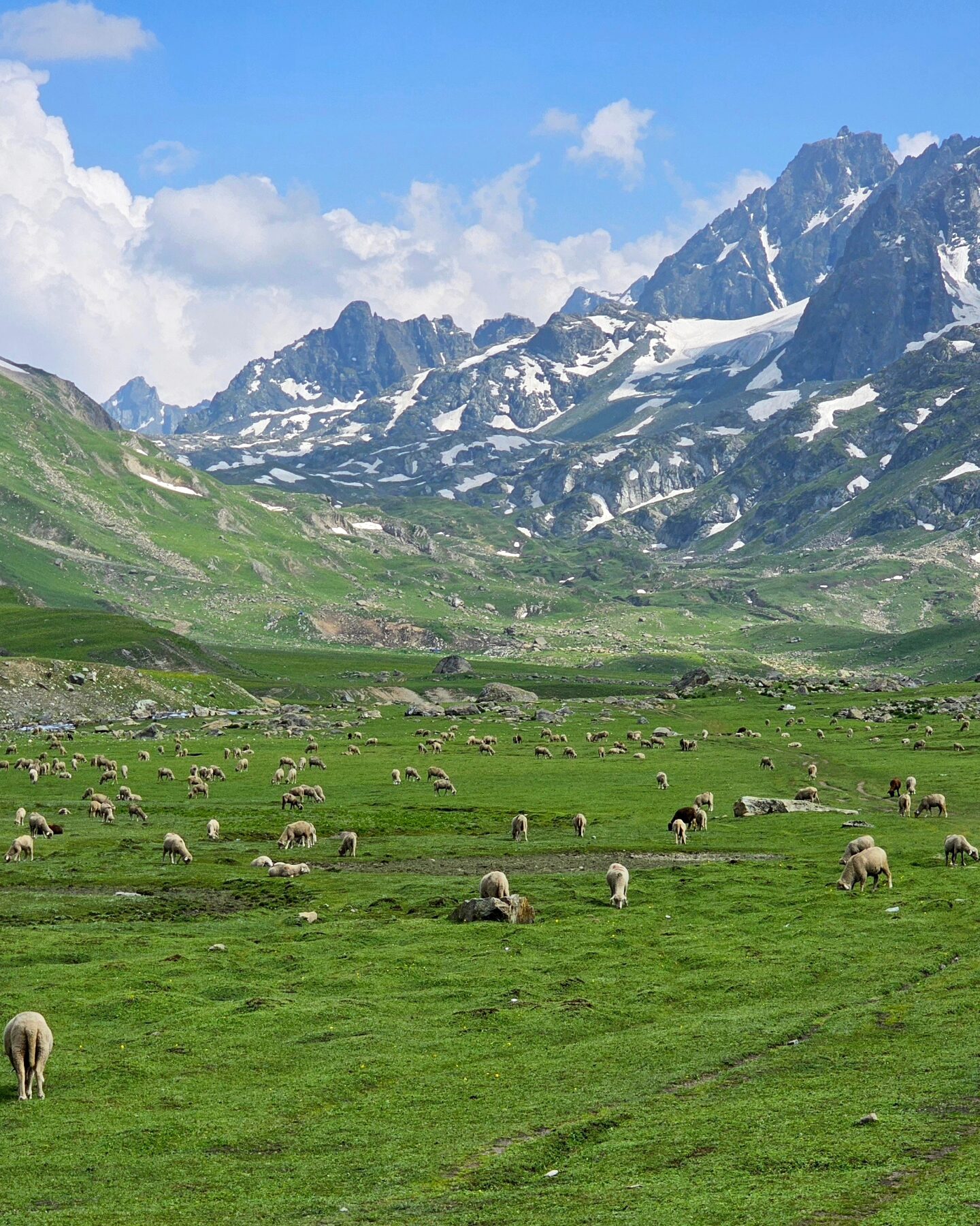
Kashmir is located in valley Himalayan Mountains. The majestic glacial terrain attracts people from all over the world who love mountaineering and hiking. The most famous hiking route is the Seven Great Lakes Trekking . In addition to admiring the layers of scenery while walking, In addition to the stacked majestic peaks, the extending and intertwined longitudinal valleys, and the endless alpine grasslands, the most fascinating thing is the clear lakes lying quietly at the foot of the mountains, with the lake surface reflecting the blue sky and white clouds. The lake height is 3,500-3,500 meters. Between 3,800 meters. Kashmir Great Lakes is one of the most beautiful treks in India. No question. It validates Kashmir’s mythical status as heaven on earth.
This is because the trek is set on a canvas that’s larger than life. It is situated 75 km northeast of Srinagar. Every day is a 360° panorama of wild, rugged mountains, rolling meadows, and turquoise alpine lakes. And you get more than seven of these lakes and five very different valleys to explore!
The range of landscape makes it a moderate-difficult trek spanning over six days. This means it has long trekking days with steep ascents and descents with no easy exit points. So, it’s not meant for a beginner who hasn’t been exposed to high-altitude treks.
Having said that, the challenges are worth it. Each day is postcard-perfect, with a new alpine lake to look forward to. What makes these lakes even prettier are the snow patches that feed these lakes. You see them sliding off the serrated mountains into the lakes. Sometimes you’ll see milky white icebergs floating on the lake’s inky blue surface. And then there are meadows of Kashmir. These meadows come in every shape and size, sometimes many in a day. After this trek, every other trek feels as though it is a movie on a small screen. Kashmir Great Lakes, however, is an IMAX 3D experience – such is the grandeur of the trek. If you have not done this trek, put it on your bucket list!
Your pick up from airport. It will take around 4 hours to reach Gagangir, the basecamp of the trek. Check-in the hotel, Your cloakroom, rentals and trek briefing will happen at sonmarg Hotel after post dinner.
• Elevation : 2630m to 3540
• Trek distance: 11.6km 6.5 Hours
Today's trek consists of 3 hour ascent followed by a 1 hour descent and finally a gentle 2 hour ascent to Nichnai. Traversing a picturesque meadow with breathtaking views of Sonmarg. Within two half an hour, you'll reach the meadow's summit, where Maple and Pine trees begin t o dominate the landscape. The trail then descends t o a small brook, only to ascend again, leading you through a dense forest o f Maple trees. The experience of walking on the lush green grass amidst these Maples is truly unique.
The trail will lead you through a picturesque Maple tree forest for the next hour and a half. Stay on the uphill path; the downhill trail will take you to nearby villages. Enjoy the scenic views of the Sonmarg valley from the clearings between the trees. As you reach the top of the ridge, the Maple forest will give way to a meadow, offering stunning views of the valley below. Please take a moment to appreciate the scene's beauty, with its streams, meadows, pines, and town nestled in the distance. After a brief climb, the trail will descend into a verdant meadow lined with Silver Birch trees and dotted with small brooks. This is Shekdur, a lovely campsite surrounded by Bhojs. If you're starting your
trek from Srinagar a t dawn, However, if you're starting from Sonamarg, it's too early to
set up camp here. Instead, take a break at the meadow before continuing to Nichnai,
the next campsite. The meadow lasts about half a n hour before reaching a forest o f Bhoj, or Silver Birch. Follow the trail through the forest and watch for the sun's rays as they filter through the dense foliage, creating a dappled pattern of light and shadow. In approximately 45 minutes, you'll reach the end of the birch tree line and begin your descent into the river valley, marking the beginning of Nichanai. The trail follows the right bank o f the Nichanai River as it flows upstream, with the snow-capped
peaks of Sonamarg Valley visible to your left. You'll traverse a wide valley flanked by
mountains, with the river Sindh flowing through it. The terrain will be rocky for the first 30 minutes, but eventually, the landscape will transform into a lush green
meadow as the river valley narrows. Look ahead to spot the Triangular Twin Snow-
capped Peaks in the distance. Choose a flat ground to pitch tents and end the first day's trek.
• Elevation: 3520m to 3800m via
4000m
• Trek distance: 13.5 km / Trek
Duration: 7 hours
Trek gradient: Moderate. 3 hours of gradual ascent followed by 1 hour of descent. Embark on a picturesque journey across meadows, with the scenery continually improving. Begin your trek by 8:00 am t o allow ample time to appreciate the surroundings. Your first destination for the day is the Nichnai pass visible from the
campsite. The pass i s a striking landmark located just right of the twin snow-capped
peaks. Following a half-hour river-side walk, cross the waterway to transition to its left bank. Observe the trail gradually ascending as you advance through the meadow for the next hour. The subsequent hour is dedicated t o a moderate climb to Nichnai Pass, standing at 4000m succeeded b y a minor descent and an extensive flat meadow walk, ultimately leading to Vishnusar Lake. As you ascend, take notice of a small lake nestled a thembase of the mountains, its deep blue hue igniting excitement for the lake. The pass is not immediately apparent from the meadow below, as the trail misleads with two inward turns before revealing the Nichnai pass. From this vantage point, take in the breathtaking views of the Sonamarg valley and the path you've traversed. As you continue your journey, the path opens into a vast, snow-covered valley, with towering peaks rising u p o n your left. The landscape on the right side slopes upward, but n o prominent peaks are in
sight. considering it's only the second day of your trek. The high altitude can be challenging, but the good news is that the trail begins to descend from here, offering
a welcome respite. The rugged terrain leads t o a steep rocky path, eventually turning into lush green grass. Bright red flowers dot the landscape, adding colour to the otherwise muted tones. Ahead, a vast meadow stretches out for miles, flanked by towering mountains. A new river flows gently through the valley, providing a soothing soundtrack to your journey. As you pause, take i n the breathtaking panorama of rugged peaks, glistening rivers, and vibrant meadows. To your left, a magnificent waterfall cascades down the mountain slope, merging with the river below. Beyond the waterfall, the terrain
flattens out, and you continue your journey through the expansive meadow. The iconic
snow-capped Himalayas rise majestically to your left, while the barren, grey
mountains o n your right evoke the stark beauty o f the Ladakh ranges. Amble along the verdant valley, flanked by two towering ranges. Two prominent streams meander through the landscape, with the left-hand stream being your guide. Prepare for a refreshing stream crossing in a mere half hour, with crisp water leaving you invigorated.
Set up camp i n the meadow for 90 minutes until you reach the valley's end. A stream
flows from the left towards the right, originating from Vishnusar Lake, located
higher up on the left but cannot be seen from the campsite. Pitch your tents in an
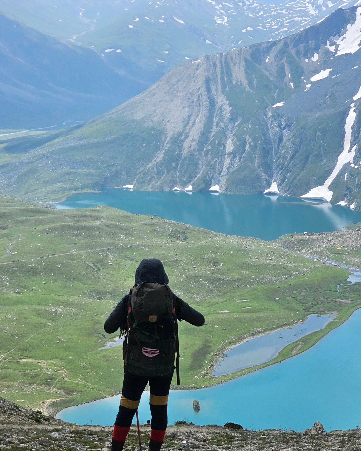
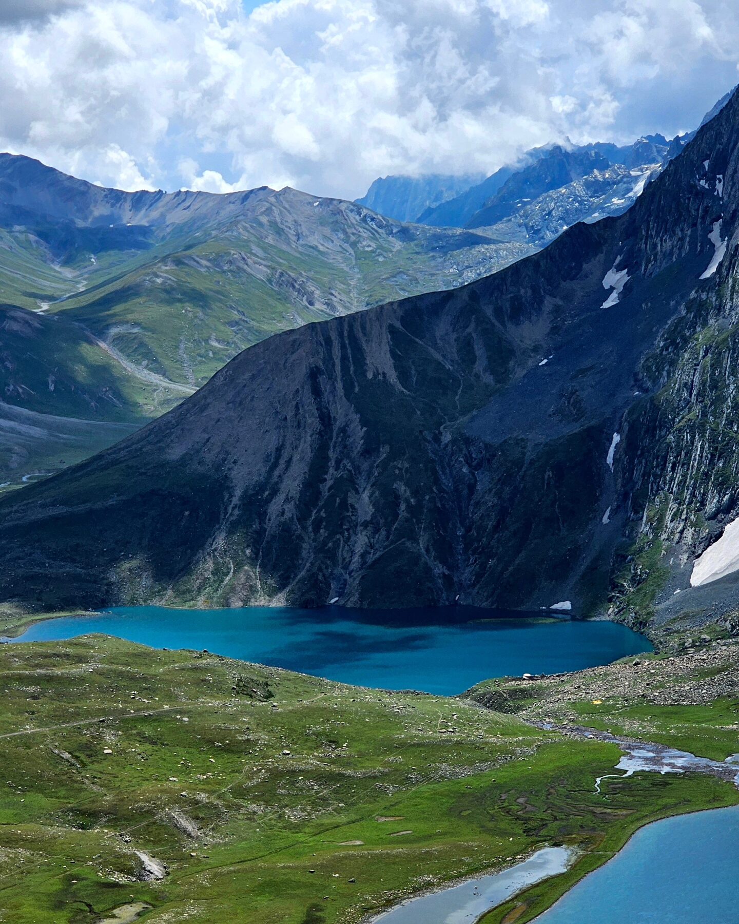
open area near the stream, leaving plenty of space for other campers. The Vishnusar lake is 0.5 k m to the left and 100 feet above the campsite. Head left and follow the stream to reach the lake, keeping i t t o your right. I t takes approximately 7 minutes to reach the lake between two mounds. The first thing you'll notice about the Vishnusar Lake is its size
and how four mountains surround it. The Kishansar peak, located 0.5 km away, is reflected in the lake's calm waters, creating a stunning visual effect. The lake's colour varies depending on the time of day and the clouds i n the sky. In the early morning, the water is crystal clear, but the lake takes on a blue hue as the sun rises. When the sun i s high i n the sky, and the clouds are few, the water appears a deep blue. However, in the late afternoon, the lake turns greenish-blue, thanks to the combination of clouds and the setting sun. Regardless of the time of day, the Vishnusar Lake is truly breathtaking and
worth seeing in its different colours.
[ ] Elevation : 3650m to 3261 via 4000m
[ ] Distance : 16 km| 08 Hours
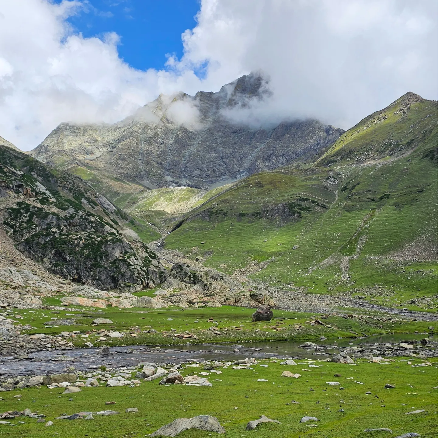
Trek gradient: Moderate difficult. 1.5-2 hours of steep ascent followed by 1 hour of steep descent, easing off into a level walk. Most difficult trial of Kashmir great lakes trek,start your day early. You’ll encounter a narrow trail that winds up the mountainside as you journey. This path will lead you to the summit, but be sure to follow the track that ascends higher, as it will provide the most scenic route. The climb should take around an hour and a half at a moderate pace, and about 45 minutes into your ascent, you’ll be rewarded with a breathtaking view of both Kishansar and Vishnusar lakes, nestled in the mountains.
The scenic view of the twin lakes persists until you reach the ridge summit or the pass, known as the Gadsar pass, which stands at 4000m feet, the highest point on this trek. The trek involves a strenuous 2-hour climb followed by a steep descent and a leisurely walk through the meadows. On the opposite side of the Gadsar pass, a long valley stretches out, with 2-3 small lakes visible in the distance. A series of snow-capped peaks can be seen on the far horizon, lying beyond our Line of Control. It is not unusual to encounter snow at the Gadsar pass and in the initial sections of the descent on the other side.
The path downward is uncomplicated. The initial minor lake on the left is Yamsar Lake, which the local population believes has a connection to Lord Yama. Following Yamsar is a second unnamed lake. A short descent of an hour brings you back to level meadows. This valley is more compact, with two mountain ranges running along its sides. Take note of the vibrant flowers growing out of the green grass, beginning with red and gradually shifting to blue and purple irises.
As you venture into the blue Iris area, you’re just a short distance from the breathtaking Gadsar lake, nestled at the foot of snow-capped peaks. Vibrant blue flowers bloom on one side, while snow slabs tumble into the lake from the mountain on the other. Ahead, the valley stretches out in a gentle green-blue slope. The Yamsar, the unnamed lake, and Gadsar are linked by a stream that flows from the higher lake to the lower, with Gadsar at an elevation of 12,500 feet.
Select Gadsar as your campsite for its breathtaking beauty, but only if you promise to leave the area as pristine as you found it. Gadsar is typically unoccupied, and a small, abandoned military shelter is nearby.
If you opt not to set up camp beside Gadsar, the next suitable location would be the army camp nearby. Following the downward trail from Gadsar, the valley expands after a half-hour walk, revealing a second blue lake on the left-hand side. The snow-capped mountains give way to rugged, barren peaks. You’ve descended a significant amount of altitude. Another half hour down the trail, a few shepherds’ huts come into view. Continue downhill for three and a half hours, and the army camp will be at the end of your journey. Mountain permits and identify( Passports) will be checked by military after complete the formalities walk 5 minutes to campsite surrounded by mountains.
[ ] Elevation: 3261 to 3650
[ ] Distance: 11.5 | 06 hours
Trek gradient: Moderate; 1.5 hours of steep ascent followed by a level walk.
After crossing the stream through snow bridge, follow the trail that ascends the mountain, reminiscent of a typical western ghats path. You’ll feel above the tree line, with the tree-covered valley stretching below. The 1.5-hour climb, and the trail will eventually transition into a traverse. Catch the magical view of Nanga parbat 8126m ninth highest peak of world. We’ll leave the river valley behind and find yourself walking on a flat trail surrounded by mountains, with deep craters to your right. This area is known as Maengandob. The landscape ahead is breathtaking, with isolated mountains and a small ridge to your right. In between, you’ll find a flat green bed with a river flowing through it. Consider camping here if Gadsar Lake is your last stop. If you started at the army camp, it’s worth covering a bit more distance and setting up camp near the first of the Satsar lakes. Satsar consists of seven lakes, four or five containing water depending on the season. Located beyond the ridge on the right is the Satsar army check post, the third line of defence from the LOC. Expect to go through the usual identity checks, collection, and questioning process. It’s best to take care of this today to ensure a smooth and enjoyable trekking experience tomorrow. Just ten minutes from the army camp is the first of the Satsar lakes, a picturesque body of water nestled in a green setting with mountains rising in front. Choose a suitable spot to set up camp for the day.
[ ] Elevation: 3657 to 3270m via 4000m
[ ] Distance: 9km | 06 hours
Trek gradient: Difficult. 30 minutes each of gradual ascent and descent followed by a steep ascent for about 45 and then by a steep descent. Similarly ascending and descending trail all the way through.
The terrain undulates throughout the day’s trek, alternating between gentle inclines and declines, followed by a steep ascent and descent. The path replicates this pattern, consistently rising and falling. Begin by trekking for half an hour to reach the largest Satsar lake, traversing bouldery terrain requiring more hopping than walking. Beyond the final lake, the trail descends, and after a 30-minute walk, the forest line comes into view on the left, while a ridge line lies to the right. It’s time to gain altitude again. Use the zig-zag pony track to ascend the first ridge, a 45-minute journey with limited breaks. From the summit, two additional ridges remain to be climbed. The barren and rocky trail offers a contrasting view of the adjacent mountains, where Gujjar huts are visible amidst tall pines. The disparity between the arid mountains and the lush greenery on the other side is striking.
After a two-hour ascent, you reach the summit of the third ridge, where you’re greeted with a breathtaking view. The altimeter shows an elevation of approximately 4000m Zaj pass the third pass of seven lake trekking. The real treat, however, is the stunning panorama that unfolds before you. Two lakes sit side by side, with a stream flowing from the higher lake to the lower. Look closely and spot two more lakes in the distance, one on either side. The largest of the four lakes is Gangabal, and its companion is Nandkol. Your destination is now clearly visible. The path ahead involves a brief descent. Take in the scenery and get ready for a challenging descent. Your final destination is Nandkol. While the ascent is dry, you’ll cross a stream midway through the descent. Fill up your water bottles and press on. The steep descent takes about an hour and a half, after which you’ll find yourself in a lush green meadow. The meadow stretches from right to left, and a kilometre down the left, you’ll see the tree line again. Once you reach the base, the lake shore is still far off. Though the destination is now visible, it appears distant. The area is littered with remnants of camping. Many people trek up from Naranag to Gangabal and return as a weekend getaway, leaving behind a trail of garbage.
The picturesque Nandkol Lake is situated at the foot of the majestic Harmukh Peak, with the Harmukh Glacier gracefully descending the rocky slopes. Both Nandkol and Gangabal Lakes are renowned for their excellent trout fishing spots. While Gangabal Lake is a 20-minute trek away from Nandkol, a fiery stream flows between the two lakes, connecting them.
Today's difficulty level is light, the walking time is 2 hours, the walking distance is 5 kilometers, and the elevation gain is about 100 meters. After breakfast, pack lightly and head to Gangabal, the largest lake on this hike, to see another glacier entrenched in the holy mountain. There is a small cave on a big rock on the shore of Gangabal Lake that is similar in shape to the cave of Lord Shiva in India. After the Indians who loved making gods took over Kashmir, they named the lake Gangabal, which is the Ganges River. Therefore, it attracts tourists every summer. Pious Hindus come for pilgrimage. Walk around the lake and find the best view to see the blue sky and white clouds. At this moment, your worries seem light and gentle. Gangabal Lake is crescent-shaped, and it takes about 5 to 6 hours to circle around the lake. The lake is rich in fish stocks and is known as the hometown of trout. Every year, it attracts countless local fishermen to go up the mountain to enjoy the pure fun of fishing. Take off your heavy hiking boots and walk slowly back to the camp area.
[ ] Elevation: 3270 to 3300m via 3750m
[ ] Distance : 11km | 06 hours
Start your day with amazing view of Harimukh mountain, cross the wooden brige climb 300m. The steep slope ends and you come to a resting point where you can overlook another side of the Nundkol Lake.Then walk up a gentle slope for about half an hour to reach a wide prairie, where you can admire the glaciers of Harimukh Holy Mountain. Arrive at Kulsar Lake, with an altitude of 3,750 meters, the highest among the seven lakes. Stay at the lake for an hour to have a meal, and then proceed to Trunkund, today's camp. After leaving Kulsar Lake, walk down the moraine piles in the river valley to the military camp checkpoint for 1 to 2 hours. At the checkpoint, you need to check the mountain entry permit and passport, and you will also be asked to turn on your mobile phone camera and carry-on backpack. This is the Seven Great Lakes The strictest checkpoint on the hiking trail. Arrive at Trunkund, the last camping area of the hike. Nearby is an alpine coniferous forest with scattered wood that can be picked up and a campfire can be lit at night
• Elevation: 3300m to 2200m
• Distance: 11km / 5 hours
Today's difficulty level is low, with a walking time o f 5 hours, a walking distance of 11 kilometers, and an altitude drop of about 1,100 meters. On the last day, we will descend 1,100 meters from the camp's height of 3,300 meters to the end point of Naranag. The first half o f the 2-hour walk is quite easy.Most of the trails today are on gentle slopes in the alpine pine forest area.In the last more than an hour, we descend steeply to the end of Naranag. After arriving, we can visit the ruins of a thousand-year-old Indian temple. Finally we drive 2 hrs to Houseboat in Srinagar take a shower refresh then Evening is free to explore Dal lake via Shikara ride.
After breakfast finally take everyone to the airport or to their next travel destination with happy memories.
The Kashmir Great Lakes Trek is ideal for fit beginners to intermediate trekkers. You don’t need technical climbing skills, but you should be comfortable with multi-day trekking at altitude.
It’s a moderate to challenging trek. Expect long walking days (6–8 hours), steep ascents, and high-altitude passes above 4,000 meters.
The trek reaches around 4,200 meters (13,800 ft) at its highest passes.
The ideal season is:
Not mandatory, but recommended. If you have done any multi-day trek, it will help you enjoy this experience more.
You will stay in high-quality tents throughout the trek. Campsites are set near lakes and meadows with stunning views.
You should have good cardiovascular fitness. Being able to jog 4–5 km or hike for several hours comfortably is a good benchmark.
Essentials include:
(A full packing list is provided after booking.)
No. Once the trek begins, network coverage is extremely limited or non-existent.
Yes, when done with experienced operators. Himalaya Alpine ensures:
Member Since 2026


Leave a review